In This Article
- A Portrait Five Years in the Making
- Why Perseverance Drove This Far West
- How Did Perseverance Actually Take This Selfie?
- What the Arbot Panorama Reveals About Ancient Mars
- What Comes Next — and Why It Matters
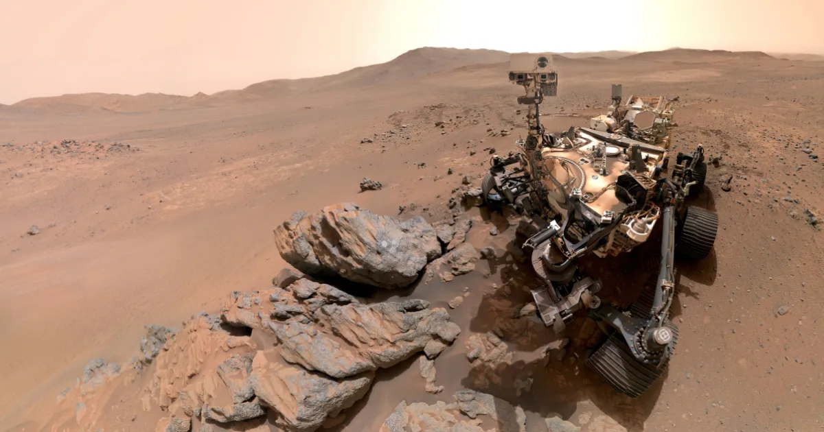
On the 1,797th day of its mission, a car-sized robot stopped in the middle of an alien desert, raised its arm, and took a photo of itself. That sounds routine until you understand what it was standing on: rocks that formed before Jezero Crater even existed, at a location no spacecraft had ever reached, roughly 26 miles from where it first touched down. The Perseverance rover's sixth selfie is not just a pretty picture. It marks the opening chapter of the most geologically ambitious stretch of the Mars 2020 mission.
A Portrait Five Years in the Making
Perseverance landed inside Jezero Crater in February 2021 with a mandate straightforward in ambition and staggering in complexity: find signs of ancient life, collect rock samples for eventual return to Earth, and map the geology of a place that was once a lake. For the first four science campaigns, the rover stayed within the crater and its ancient river delta.
The fifth campaign changed the terms entirely. The science team pushed the rover west, beyond the crater rim, into terrain they call the Northern Rim region. The site where the selfie was taken, a patch of Mars nicknamed "Lac de Charmes," represents the deepest incursion into that unexplored frontier yet. The crater rim is visible in the background of the portrait not as a boundary the mission is approaching, but as a landmark it has already left behind.
Why Perseverance Drove This Far West
The river delta inside Jezero was scientifically rich because sedimentary rock preserves biological signatures well. But sedimentary rock tells you about water and surface processes. To understand what Mars was made of at its core, what drove its volcanic history, and whether it ever had conditions warm enough for life to begin, you need to get underneath all of that. You need igneous rock.
The Arethusa outcrop, the rocky target at the center of the selfie, turned out to be exactly that. After the rover ground down a circle on its surface in a technique called abrasion, the science team determined it contains igneous minerals with large crystals, the kind that form when molten rock cools slowly deep underground. These rocks appear to predate Jezero Crater itself, placing them at over 3.9 billion years old. That puts them in a different category of scientific target entirely.
How Did Perseverance Actually Take This Selfie?
Taking a selfie on Mars requires more engineering elegance than pointing a smartphone. Perseverance has no mirror and no fixed front-facing camera. Instead it relies on WATSON, the Wide Angle Topographic Sensor for Operations and eNgineering, a camera fixed to the end of its robotic arm. To build a composite image, the arm executes a precise choreography: 62 individual movements, each aimed at a slightly different angle, all completed in roughly one hour. The 61 resulting frames are then stitched together on Earth.
The result looks effortless. The rover appears to gaze directly at the viewer, its mast steady, its dusty chassis catching the pale Martian light. In reality, the arm that holds the camera is absent from the final image because the compositing process removes it, much like a photographer cropping out their own hand from a reflection. This was Perseverance's sixth selfie since landing in 2021, and by scientific location, its most significant.
"We took this image when the rover was in the 'Wild West' beyond the Jezero Crater rim — the farthest west we have been since we landed at Jezero a little over five years ago."
— Katie Stack Morgan, Perseverance Project Scientist · NASA JPL, 2026What the Arbot Panorama Reveals About Ancient Mars
The selfie was not even the most scientifically striking image released alongside this update. On April 5 (Sol 1,882), Perseverance used its Mastcam-Z instrument to capture a 46-image panorama of the "Arbot" area nearby. The team's deputy project scientist Ken Farley of Caltech described it as offering "excellent exposure of likely the oldest rocks we are going to investigate during this mission."
The image reveals a landscape of startling geological variety. A sharp, angular ridgeline cuts across the background, its jagged texture contrasting with smooth, rounded boulders in the foreground. Farley identified a feature that may be a volcanic dike, a vertical intrusion of magma that hardened in place and stood as the softer rock around it eroded away across billions of years. There is also evidence of megabreccia: enormous rock fragments, some the size of skyscrapers, blasted across the landscape by a massive meteorite impact on a nearby plain called Isidis Planitia around 3.9 billion years ago.
What Comes Next — and Why It Matters
Perseverance is not done with this region. After completing work at Arbot, the rover will drive south to a site called "Gardevarri," where researchers expect clear exposures of olivine-bearing rock. Olivine forms in cooling magma and carries precise information about the thermal and chemical conditions of Mars' volcanic past. From there, the rover heads southeast toward "Singing Canyon," another target rich with early-crust rock.
The mission's sample cache grows in parallel. Perseverance has now collected 27 rock cores, 25 of them sealed, in tubes it carries onboard or has deposited as a depot on the surface. Those samples represent the scientific payload for a future Mars Sample Return mission, though that mission's timeline remains under active discussion. In the meantime, the rover itself keeps moving. Over five years of surface operations it has driven nearly 26 miles, just under a marathon. Every kilometre west now is terrain the science team has never seen.
- Oldest rocks yet targeted — The Arethusa and Arbot outcrops predate Jezero Crater, pushing the mission's geological record back to Mars' earliest crust.
- Selfie as science marker — The sixth self-portrait documents a specific abrasion site and provides mission-wide geographic context, not merely a milestone photo.
- Marathon rover, ultramarathon mission — With nearly 26 miles driven and five science campaigns complete, Perseverance is entering its most geologically ambitious phase with the rover still in excellent health.
"These rocks — especially if they're from deep in the crust — could give us insights applicable to the entire planet, like whether there was a magma ocean on Mars and what initial conditions eventually made it a habitable planet." — Katie Stack Morgan, NASA JPL, 2026.
📄 Source & Citation
Primary Source: NASA Jet Propulsion Laboratory (2026). NASA's Perseverance Rover Snaps Selfie in Mars' Western Frontier. NASA.gov. nasa.gov/missions/mars-2020-perseverance
Authors & Affiliations: Katie Stack Morgan (Project Scientist, NASA JPL); Ken Farley (Deputy Project Scientist, Caltech); Steve Lee (Acting Project Manager, NASA JPL). Operations managed by NASA JPL for NASA's Science Mission Directorate.
Data & Code: Raw imagery available via NASA Mars 2020 Raw Images. WATSON imagery operated by Malin Space Science Systems, San Diego.
Key Themes: Perseverance Rover · Mars Geology · Igneous Petrology · Jezero Crater · Mars Sample Return
Supporting References:
[1] NASA JPL (2026). NASA's Perseverance Captures Panorama at 'Arbot'. NASA Photojournal.
[2] NASA JPL (2026). NASA's Perseverance Rover Snaps Westernmost Selfie. NASA Photojournal.
[3] Stack Morgan K. et al. (2024). Geology of Jezero Crater and the Mars 2020 landing site. Science, 377(6614).
No comments yet. Be the first to share your thoughts.
Leave a Comment