In This Article
- The Ocean Signal That Shocked Scientists
- What Is El Niño and What Makes It "Super"?
- Why Is the Pacific Heating So Fast in 2026?
- What Will a Super El Niño Do to Our Weather?
- What Happens Next, and What Can We Do?
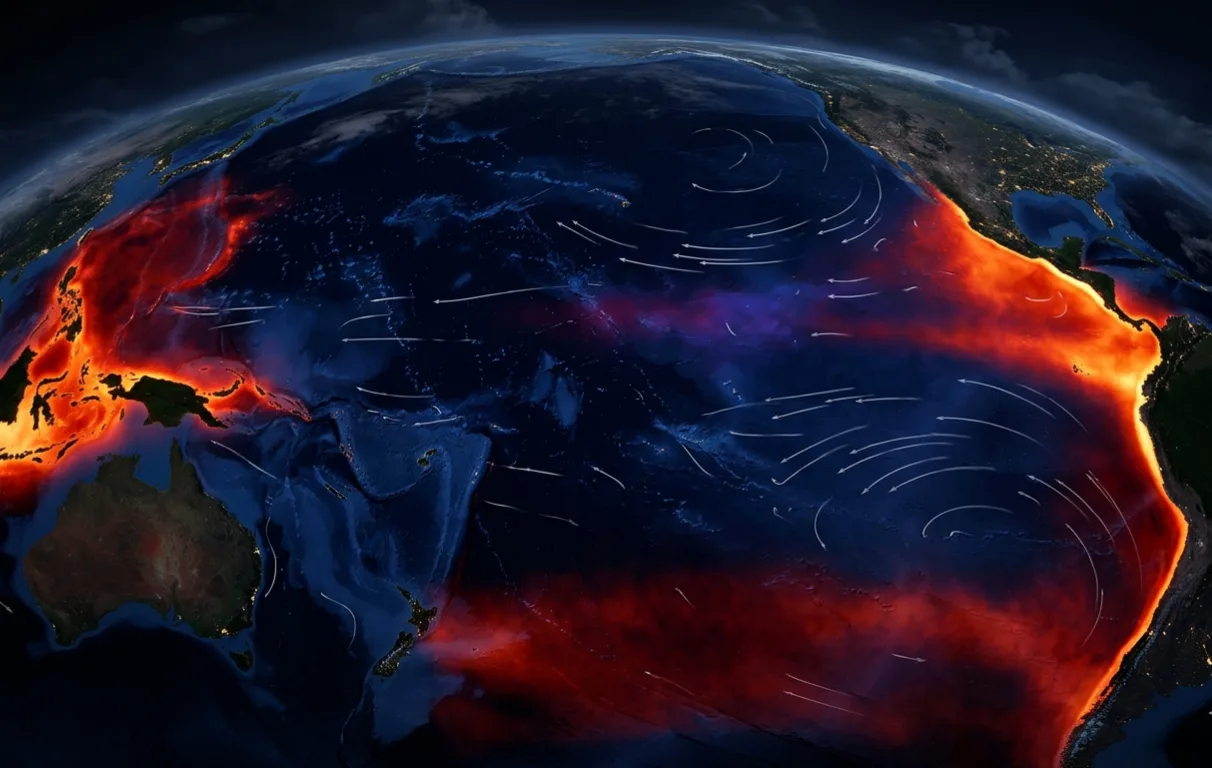
Something strange is happening at the bottom of the Pacific Ocean, and it is moving fast. A giant wave of warm water, bigger than the continent of Australia, has been quietly building under the ocean's surface for months. Now it is rising. Scientists who track the world's climate say this hidden heat is about to break the surface and change the weather for billions of people, including you.
The Ocean Signal That Shocked Scientists
In the early months of 2026, climate researchers noticed something they had never seen before. Warm water was forming in three different parts of the tropical Pacific Ocean at the same time, near Indonesia, near Central America, and near South America.
Together, these three warm patches formed a ring around a cooler centre, like a hot circle on the map. Researchers at the Second Institute of Oceanography in China confirmed this is the biggest such pattern seen in at least 40 years. Not even the powerful El Niños of 1997 or 2015 showed this exact shape.
And below the surface, the ocean is storing even more heat than it is releasing. Think of it like a pressure cooker that keeps building steam. That stored energy is now moving east across the Pacific, and the lid is about to come off.
What Is El Niño and What Makes It "Super"?
Every two to seven years, the Pacific Ocean naturally swings between warm and cool. When it swings warm, we call it El Niño. When it swings cool, we call it La Niña. The world has been in a La Niña phase, meaning cooler than normal, for the past couple of years.
But that cool phase is now ending very quickly. A massive underwater surge of warm water, called a Kelvin wave, has been pushing heat towards the ocean's surface much faster than scientists expected earlier this year.
A normal El Niño raises ocean surface temperatures by about 0.5 degrees Celsius above average. A Super El Niño pushes that rise past 2 degrees Celsius. That may sound like a small number, but in ocean terms it is enormous, enough to reroute monsoons, trigger wildfires, and starve coral reefs across entire ocean basins.
Why Is the Pacific Heating So Fast in 2026?
In March 2026, just two months ago, climate models gave only a 22% chance of a Super El Niño forming this year. By late April, that number had jumped to 80%. Today, the European Centre for Medium-Range Weather Forecasts, the world's leading weather prediction body, puts the chance at 100%.
The speed of this shift surprised even the experts watching it. The reason it is happening so fast comes down to two things happening at the same time. First, that unusual ring of warm water in three separate parts of the Pacific created a natural funnel, pushing energy towards the centre. Second, a burst of strong westerly winds in late March acted like a trigger, pushing warm surface water further east along the equator.
The National Oceanic and Atmospheric Administration confirmed that sea surface temperatures in the Pacific were already near all-time highs in April 2026, even before El Niño conditions have officially begun. The ocean is not just warm. It is historically warm, at a speed that models are struggling to keep up with.
"The bigger the Niño, the bigger its impacts on global weather. Once you cross the super threshold, the consequences multiply."
— Prof. Bill McGuire, UCL · HuffPost UK, 2026What Will a Super El Niño Do to Our Weather?
Here is the part that concerns everyone, not just scientists. When a Super El Niño takes hold, it does not just warm one ocean. It rewrites the weather rulebook for the entire planet.
Global average temperatures are expected to rise further. Scientists at the World Meteorological Organization say 2026 could become either the hottest or second-hottest year ever recorded. And because the peak of this event may not arrive until 2027, 2027 could be even worse.
The dangerous 1.5 degree Celsius warming limit, the line that world leaders agreed must not be crossed to avoid the worst climate damage, could be broken again this year and next. Crossing that line even temporarily carries real consequences: more permafrost in the Arctic will melt, releasing ancient gases that trap heat, and sea levels could rise by one to three feet over the coming decades.
What Happens Next, and What Can We Do?
Scientists are honest about what they still do not know. The exact strength of this Super El Niño is still uncertain because the event has not fully formed yet. The peak warming in the Pacific may not happen until late 2026, which means the worst effects on daily weather, the floods, the droughts, the heatwaves, could run well into 2027.
There is also an important limit to what any forecast can tell us. The world has never experienced a Super El Niño on top of the level of background climate warming that exists today. Every past event happened in a cooler world. This one does not, which means scientists are working with a map that has never been used before.
What individuals can do is not nothing. Preparing for extreme heat, conserving water, and supporting local farming communities through difficult seasons are all practical responses. Governments and disaster agencies in affected regions have been put on early alert by the World Meteorological Organization.
- The odds are now certain. The ECMWF puts the chance of a Super El Niño forming by November 2026 at 100%, driven by ocean warming at a speed not seen in four decades.
- India faces monsoon risk. A strong El Niño historically weakens the Indian monsoon, threatening agriculture across multiple states and pushing up food prices.
- The world is in new territory. Because global temperatures are already higher than in any previous El Niño year, the effects of this event are harder to predict and likely to be more severe than any comparison to past events suggests.
"A super El Niño later this year is likely to see the rise in global average temperature since preindustrial times smashed again. It would not be a surprise to see both this year and next year breach the dangerous 1.5 degree climate change guardrail." — Prof. Bill McGuire, University College London, 2026.
The Pacific Ocean has been the quiet engine of our planet's weather for millions of years. Right now, that engine is running hot. And what happens in the ocean does not stay in the ocean. It comes for all of us, in the form of the rain that fills our rivers, the heat that bakes our fields, and the storms that reshape our coastlines. The scientists have been watching. Now, so should we.
📄 Source & Citation
Primary Sources: Lian T, Chen D, et al. (2026). Unusual annular warming pattern in the tropical Pacific spring 2026. Second Institute of Oceanography, Hangzhou. · ECMWF Monthly Forecast Bulletin, May 2026. · World Meteorological Organization El Niño/La Niña Update, May 2026.
Authors & Affiliations: Tao Lian (Second Institute of Oceanography, China); Dake Chen (co-author); Prof. Bill McGuire (University College London, Emeritus Professor of Geophysical and Climate Hazards)
Data & Code: Sea surface temperature data via NOAA buoy network and NASA satellite observations. ECMWF seasonal forecast models publicly available at ecmwf.int.
Key Themes: Super El Niño · Pacific Ocean Warming · Global Temperature Records · Indian Monsoon Risk · Climate Extremes 2026
Supporting References:
[1] ECMWF (May 2026). Seasonal forecast update: El Niño probability. ecmwf.int.
[2] World Meteorological Organization (May 2026). El Niño/La Niña update — May 2026. wmo.int.
[3] McGuire, B. (2026). Super El Niño and the 1.5°C guardrail. HuffPost UK Climate Desk.
No comments yet. Be the first to share your thoughts.
Leave a Comment