In This Article
- A Volcano With No History Suddenly Comes Alive
- Why Tracking a Volcanic Ash Cloud Is So Hard
- How Did Scientists Trace the Plume Across Three Countries?
- What the Ash Left Behind — Including in the Ocean
- The Limits of What Scientists Know and What Comes Next
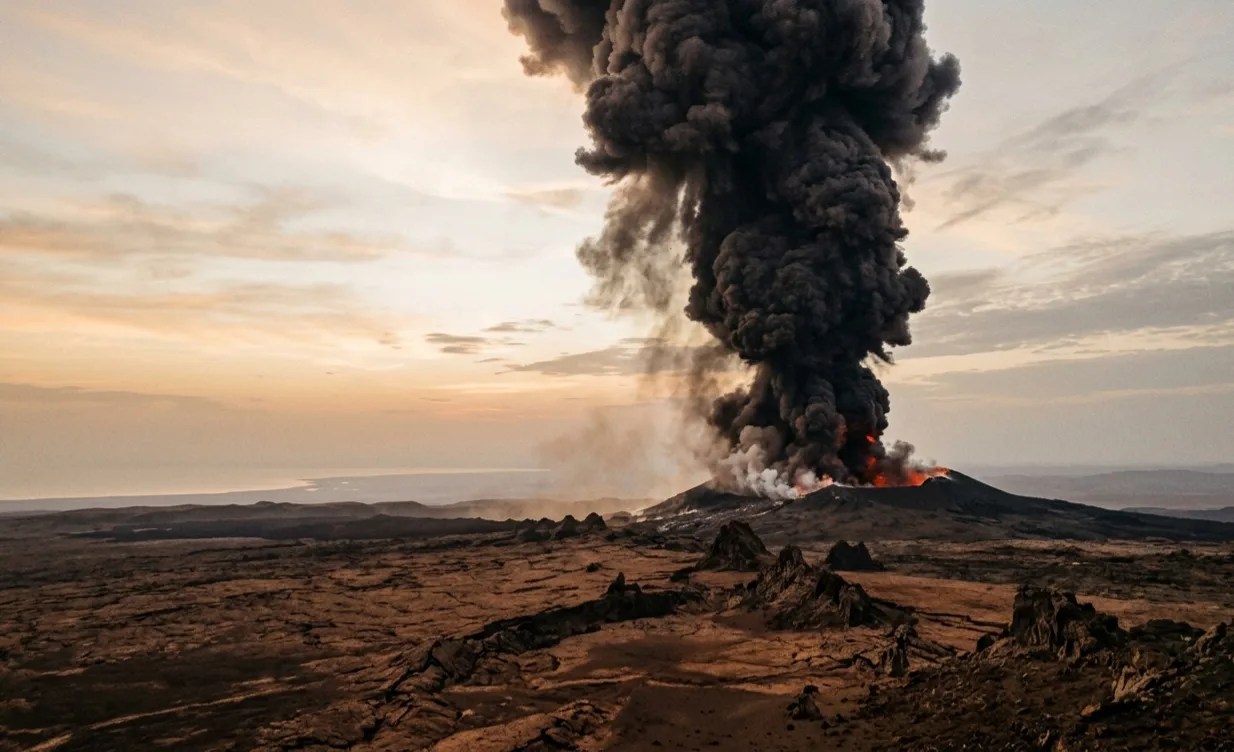
On the morning of 23 November 2025, a volcano in Ethiopia that nobody had watched closely — because it had never done anything — suddenly exploded. Within hours, a vast cloud of ash and toxic gas was drifting over the Red Sea, heading toward Yemen and Oman. A team of scientists at King Abdullah University of Science and Technology raced to track it, measure it, and understand it before it disappeared. Their findings, published in Scientific Reports, show exactly how far a volcanic eruption can reach — and how quickly.
A Volcano With No History Suddenly Comes Alive
The Hayli Gubbi volcano sits in the Afar Depression, a vast sunken plain in northeastern Ethiopia where three tectonic plates — enormous slabs of the Earth's crust — are slowly pulling apart from each other. This is one of the most geologically active places on the planet, where land is literally tearing itself open over millions of years.
Despite this violent neighborhood, Hayli Gubbi itself had been completely quiet. According to the Smithsonian Institution's Global Volcanism Program, there was no record of this volcano erupting since the beginning of the Holocene — the geological period that started roughly 11,700 years ago, when human civilization was just getting started. In other words, nobody alive today, and none of their ancestors in recorded history, had ever seen this volcano erupt.
That changed at 08:30 UTC on 23 November 2025. The first explosion sent an ash column punching upward into the upper atmosphere, and the winds immediately began carrying it eastward across the Red Sea. Regional weather authorities in Oman confirmed the cloud had crossed their airspace by 24 November.
Why Tracking a Volcanic Ash Cloud Is So Hard
When a volcano erupts explosively, it throws two very different things into the sky: ash (tiny fragments of rock and glass), and gases like sulfur dioxide, often written as SO2. Both travel with the wind, but they behave differently. Ash particles are heavy and gradually fall back to earth. SO2 is a gas that spreads more widely and stays aloft longer.
The immediate problem for any scientist watching an eruption is: how much of each was released, and from what height? The height matters enormously. Ash injected at 10 km will travel very differently from ash at 15 km, because wind speed and direction change significantly with altitude. Without knowing the height, you cannot predict where the cloud will go.
Traditionally, scientists had to wait days or even weeks to piece this together from ground observations. With air traffic at risk and people potentially breathing the ash across multiple countries, a method that takes weeks is useless in a crisis. That is exactly the problem this study set out to solve.
How Did Scientists Trace the Plume Across Three Countries?
The team introduced a new tool called Plume-traj. Think of it as a time machine for air parcels. Instead of watching the cloud move forward from the volcano, the tool starts from where the cloud was observed in satellite images — hours after the eruption — and traces each parcel of air backward through time until it arrives back at the volcano. This tells scientists exactly when and at what height each piece of the cloud was released.
The satellite doing the observing was TROPOMI, an instrument aboard the European Sentinel-5P satellite. TROPOMI scans the atmosphere daily, measuring SO2 concentrations and the position of aerosol (particle) clouds across the entire globe. The team used its data like a photograph of the plume and then ran their backward-trajectory tool to reconstruct the eruption's timeline.
"The trajectory-derived ash source term, scaled to 0.8 Mt, captures the main ash transport corridor and the timing of the coarse-mode enhancement observed by AERONET at Nizwa University, Oman."
— Ukhov, Masabathini et al., KAUST · Scientific Reports, 2026The method worked well for ash. For SO2, the backward trajectory gave a good starting point, but the team had to adjust it manually after comparing it with satellite images. The final result showed the ash was injected mostly between 7 and 15 km altitude, while SO2 reached a bit higher, between 9 and 16 km. Ground sensors at Nizwa University in Oman — part of the AERONET global aerosol monitoring network — independently confirmed that the ash arrived there at the expected time, giving scientists a rare real-world check on their computer model.
What the Ash Left Behind — Including in the Ocean
Not all the ash stayed airborne. The model calculated that about 6 percent of the total emitted ash fell back down within the first 28 hours. Most of that landed in and around the source region: Ethiopia, Eritrea, the southwestern corner of Yemen, and — notably — the southern Red Sea, which received roughly 17,600 tonnes of fine ash.
Ash falling into the sea is not a neutral event. Volcanic ash contains minerals, and when those minerals dissolve in seawater they can act as fertilizer for microscopic marine plants called phytoplankton. This has been documented after other eruptions, most famously after the Hunga Tonga explosion in 2022, which triggered a massive phytoplankton bloom visible from space.
The plume remained mostly tropospheric — that is, below the stratosphere — which means its direct impact on global climate is expected to be limited. A volcano that punches gas into the stratosphere, like the 1991 Pinatubo eruption, can cool the planet for years. Hayli Gubbi did not reach that level.
The Limits of What Scientists Know and What Comes Next
The team is explicit about what their method cannot do. The backward-trajectory approach gives a fast and useful estimate, but it is not a formal statistical inversion. In plain language: the result is a well-reasoned best guess, constrained by observations, rather than a precise answer with error bars. The SO2 total of 0.15 million tonnes should be understood as one plausible scenario, not a definitive measurement.
There was also no lidar or radar flying over the eruption in real time to directly measure where the ash column reached. The injection height estimates come from the satellite data and the model working together, which means the same data used to build the scenario is also used to check it. Independent validation was possible only at the Oman AERONET station, which confirmed plume arrival timing but could not verify total ash mass.
What the study does establish, clearly and for the first time, is a rapid-response workflow that any volcanology team can now use. The Plume-traj tool and the accompanying emission preprocessor are both publicly archived and freely available. The next time an unexpected volcano fires — and there will be a next time — scientists can begin reconstructing its cloud within hours, not weeks.
- Silence is not safety — Hayli Gubbi had no eruption in all of human recorded history. Its 2025 explosion is a reminder that dormant volcanoes, especially in geologically active zones, can wake without warning.
- Ash crosses borders fast — The cloud covered over 2,000 km in under 24 hours, affecting Yemen and Oman. Knowing where ash will go, and how quickly, has direct consequences for aviation and public health.
- Faster tools save lives — The Plume-traj workflow reduces the time needed to reconstruct a volcanic emission scenario from days to hours, making it a genuinely useful hazard-response tool for future eruptions.
"This study demonstrates a rapid, observation-constrained reconstruction for a single-eruption case study." — Ukhov, Masabathini et al., Scientific Reports, 2026.
Hayli Gubbi had been silent for the entire span of human civilization. Its sudden return is a reminder that the Earth does not consult our records before it acts, and that the best tool against a surprise is a method already sharpened and ready to use.
📄 Source & Citation
Primary Source: Ukhov A, Masabathini S, Pateraki M, Papagiannopoulos N, Hoteit I. (2026). In the wake of the Hayli Gubbi eruption. Scientific Reports. https://doi.org/10.1038/s41598-026-56967-8
Authors & Affiliations: Alexander Ukhov, Sateesh Masabathini, Marianthi Pateraki, Nikolaos Papagiannopoulos, Ibrahim Hoteit — Division of Physical Sciences and Engineering, King Abdullah University of Science and Technology (KAUST), Thuwal, Saudi Arabia.
Data & Code: WRF-Chem code and namelists archived at Zenodo 18083573. Plume-traj tool archived at Zenodo 18096229. TROPOMI data via EUMETSAT. AERONET data via NASA GSFC.
Key Themes: Volcanic Eruption · Ash Transport · Sulfur Dioxide · Atmospheric Modeling · Hazard Assessment
Supporting References:
[1] Ukhov A et al. (2025). Enhancing volcanic eruption simulations with WRF-Chem v4.8. Geoscientific Model Development, 18(23):9805–9825.
[2] Stenchikov G, Ukhov A et al. (2021). How does a Pinatubo-size volcanic cloud reach the middle stratosphere? Journal of Geophysical Research: Atmospheres, 126(10):e2020JD033829.
[3] Barone B et al. (2022). Satellite detection of a massive phytoplankton bloom following the 2022 Hunga Tonga eruption. Geophysical Research Letters, 49(17):e2022GL099293.
No comments yet. Be the first to share your thoughts.
Leave a Comment